
Over the last few years, public lands across the country shut down due to the pandemic. As they continue to reopen, attendance has risen to record numbers. While this resurgence is a testament to the unique role open spaces play in providing spaces to experience the natural beauty and recreation our nation has to offer, many are experiencing overcrowding and access issues. Overcrowding can detract from the overall experience visitors came for in the first place—or even prohibit visitors from accessing the space altogether, due to parking or space limitations. So how can engineers and planners help agencies managing these spaces to provide the best overall experience for visitors while embracing higher attendance rates?
Our team has successfully leveraged crowd-sourced data to increase user experience while maintaining or increasing attendance for several agencies. Here is a case study on the latest of those partnerships that I hope you will find helpful in developing your plan to improve public access, while preserving the experience sought by visitors.
Midpeninsula Regional Open Space District
Located just a few miles from Silicon Valley, the Midpeninsula Regional Open Space District (Midpen) manages more than 65,000 acres of open space across 26 preserves in the Santa Cruz Mountains region in California. The preserves comprise over 250 miles of trails through scenic natural areas including coastal redwood groves. Combined with a close proximity to the metropolitan area of the San Francisco Bay Area, this results in a high visitation demand at the preserves.
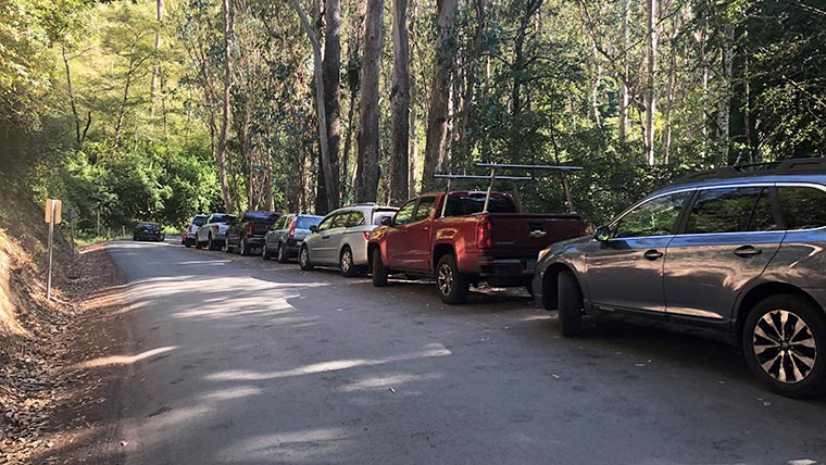
With the influx of vehicles driving to the preserve access to parking at Purisima Creek Redwood Preserve had become an issue. Midpen partnered with our team to conduct a multi-modal access study and provide direction on how to reduce overcrowding at parking areas.
Leveraging anonymous crowdsourced data tools to determine existing trends and path forward
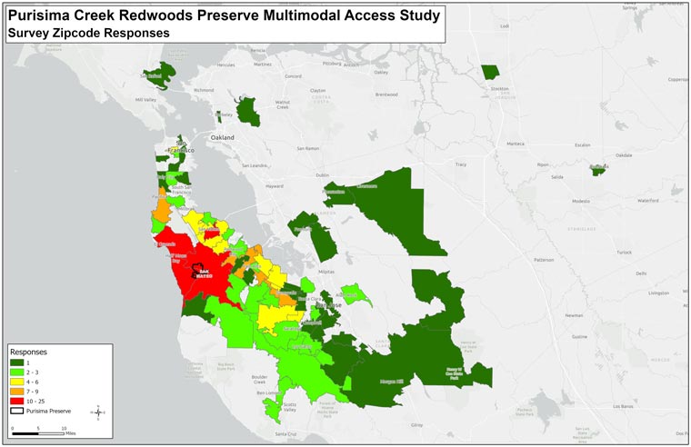
Our team is using several data tools, such as fitness app trackers and vehicle license plate scanners, to determine existing trends. The data used is publicly available and anonymous, and the privacy of citizens is not in any way compromised during this process. Data measurements used include:
- Peak preserve utilization times
- Daily visitor/vehicle ratio
- Visitor origins and destinations
- Popular trails and roads for hiking and biking
- Average length of visit
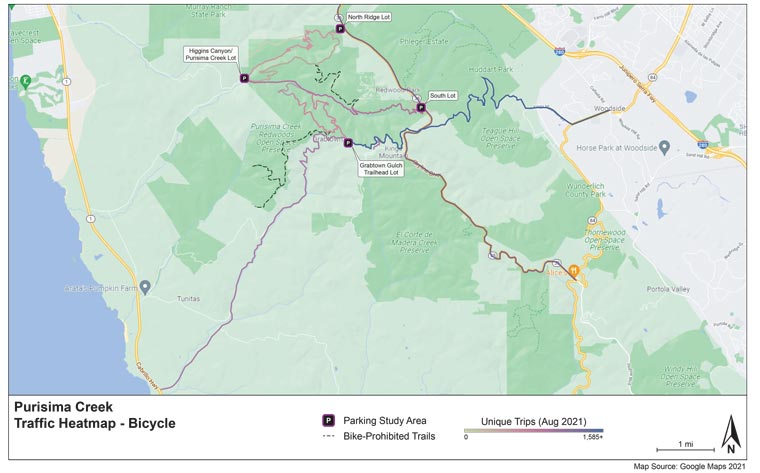
The anonymous data is then further grouped when analyzed by in-house analysts. They then use tools such as Microsoft Power BI and Tableau to develop visual aids (charts, graphs, etc.) that paint a picture of what users are currently experiencing. Our team will use this information to help Midpen make strategic decisions on what should be addressed to promote visitor experience, such as expanding parking lots in high-traffic areas, enhancing on-road bicycle infrastructure, and developing mobility solutions such as transit to the preserve shuttles.
Applying this case study to your public lands project
If you are experiencing higher attendance at your recreational site that is impacting your visitor’s experience, conducting a study will allow you to make an informed and strategic plan for areas that should be addressed. For smaller facilities, techniques like visitor and vehicle counting, conducting surveys, and hosting public forums may be sufficient. For larger facilities or facilities that want to prepare a long-term strategic plan, crowdsourced data tools provide a much more in-depth and accurate look at your visitor’s experiences.
Additionally, there are many grants available to assist public land managers with implementing their strategic plans. You can visit Grants.gov to search an entire database of current and forecasted grants. Our planners routinely work with agencies to prepare grant applications. When applying for grants, having a clear, concise and data-driven strategic plan goes a long way in obtaining the funding you need. Here are some additional tips to consider when applying for project funding.
It is a delicate balance to maintain access, while protecting the health of the natural environment that draws visitors in the first place. Incorporating crowdsourced data allows us to help our clients better understand visitor access patterns and hiking and biking preferences, so that our communities can enjoy our public open space lands for years to come.