
The last five years in the world of transportation planning and engineering can safely be described as the “Vision Zero Era.” In a field where new hot topics crop up every year, the Vision Zero concept has shown real staying power. Wherever you happen to be, dear reader, your state, county, or municipality almost certainly has some sort of policy, plan, or initiative, either on the books or in planning, that has the word “zero” in the title.
As a country, we’ve cut roadway deaths by roughly two-thirds over the last 40+ years, largely by concentrating on making the cars safer and eliminating drunk driving. Vision Zero postulates that in order to tackle that remaining third, we must address every conceivable factor that may in some way contribute to deaths and injuries on our roadways.
For the transportation planning profession, that translates to two primary impacts:
- State and local governments are much more likely to pursue standalone roadway safety planning. Whereas safety in the past had generally been approached as a single aspect of roadway design, a box to be checked, now states and municipalities want it approached in a broad fashion, incorporating numerous behavioral and infrastructure factors.
- There is, as of yet, no standard approach for pursuing the Vision Zero goal. There’s no standard manual for pursuing a Vision Zero approach. For the time being, state DOTs, city, and county governments are free to define what the primary factors to improve safety are for them.
These two factors, coupled with increasing availability of comprehensive travel data, has created a heyday for creative approaches to roadway safety. Mead & Hunt’s transportation staff have had the opportunity to contribute to a variety of innovative roadway safety efforts in the Mid-Atlantic region, ranging from targeted data dives to long-term strategic planning efforts.
Data-Driven Approaches
One cornerstone of the Vision Zero concept is the understanding that data should drive the identification of where and how to invest resources for the greatest impact. The accessibility and ease of manipulation of data from police citation databases, detailed crash records, and fine-grain travel behavior data derived from cell-phone tracking have created the ability to quickly see trends that previously were painstakingly hard to reveal. In a very real sense, the quality of data visualization tools has become the bedrock for strategic safety planning.
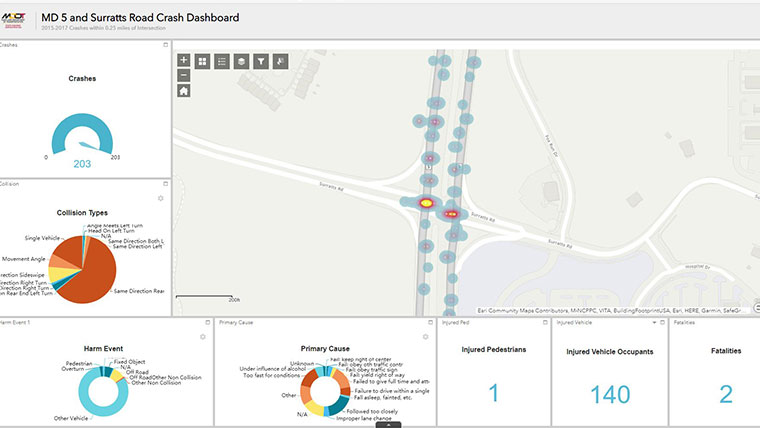
Mead & Hunt provided GIS support for the Maryland Department of Transportation State Highway Administration (MDOT SHA) by evaluating existing conditions for pedestrian safety. Our team developed an ArcGIS Web Dashboard Application to analyze crash data, pedestrian and roadway infrastructure, and citizens complaint data; and compiled data from various source to analyze pedestrian safety conditions.
We’re currently underway a Crash Reduction Plan for the City of Baltimore to support the City’s Strategic Transportation Safety Plan and Vision Zero program. The review and development process has included identifying gaps in existing crash data and any data processing issues, and making recommendations to address data quality. The crash hot spot identification and analysis has included network screening (e.g. identifying sites with potential for crash or severity reduction) based on statistical analysis to normalize the crash data, including weighting for severity and conversion to crash rates based on available vehicular volumes (e.g. turning movement counts and ADTs). Site assessments identified similar characteristics between hotspots to select appropriate countermeasures.
Strategic Safety Plans
If understanding the data is half of the battle, prioritizing the response is the other half. This means developing comprehensive safety plans to target responses and develop approaches with broad buy-in across local governments. Comprehensive long-range roadway safety plans can take on a variety of forms at the state or local level. The focus can be on a relatively small, targeted set of acute problems to solve, or seek to include all conceivable actions under a single umbrella.
The Maryland Strategic Highway Safety Plan (Zero Deaths Maryland) focuses on six emphasis areas: aggressive driving, distracted driving, infrastructure, impaired driving, occupant protection and pedestrian/bicycle. Within each emphasis area, concrete measures are developed and pursued related to the “4 E’s” of enforcement, education, engineering and EMS. While Zero Deaths Maryland is a five year plan, the efforts of the emphasis area teams is continuous. Mead & Hunt served a role of support and coordination first for the ped/bike team, and then eventually for all of the emphasis area teams.
For Frederick County, MD, Mead & Hunt is facilitating the creation of a Towards Zero Deaths plan from beginning to end. Efforts to date have included in-depth data analysis and stakeholder coordination, which have identified three primary issues to target for the county’s planning efforts: speed management, school zone safety, and infrastructure standards.
While roadway safety planning is not a new area of practice, the recent light shone on it by the Vision Zero concept and the expanded access to robust datasets on which to base decision-making have created increased opportunities for innovative solutions to be applied in the pursuit of safer roadways. Mead & Hunt’s transportation group have actively engaged in pushing the state of practice in this area, and we will continue to remain engaged in implementing solutions to the benefit of our clients and communities.